NecklaceValley_Pano.jpg

Necklace Valley

The Foss River “Full” Necklace Loop. Alpine Lakes Wilderness.
GPS Data:
Video Recap Short Version:
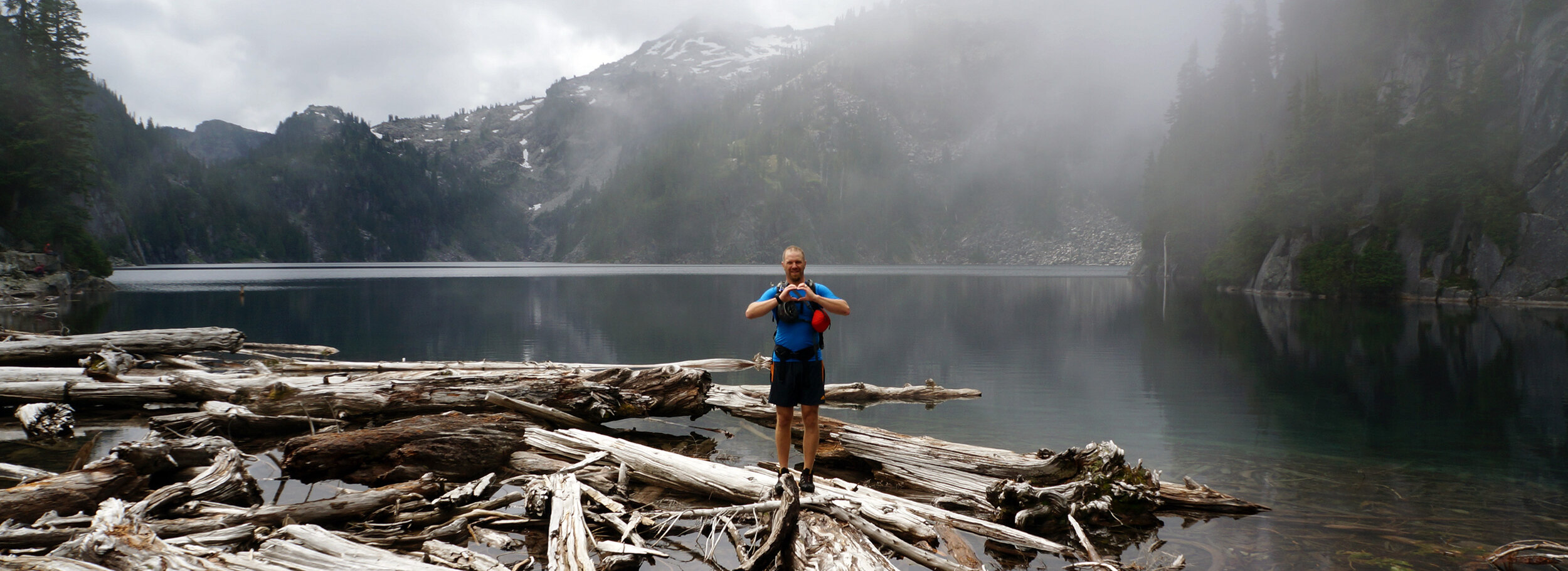
Summary: • 2 River Drainages • 1 Mountain Traverse • 17 Lakes • 16.5 Hours • 27.5 Miles • 12,900 Feet Cumulative Gain • 1,000,000,000 Mosquitoes • 1 Epic Awesome Hike


Well-traveled trails on the West Fork of the Foss River to Big Heart Lake and the East fork of the Foss River to Opal Lake can be connected via the High Alpine Route over or around Iron Cap Mountain. Start from the Necklace Valley Trailhead heading towards the West fork of the Foss River Trailhead to Trout Lake. Climb up the valley past old growth trees and dramatic waterfalls to Copper Lake.

Wrap around Copper Lake to Little Heart Lake before winding and climbing up then back down to Big Heart Lake. The trail continues on the East Ridge between Big Heart and Angeline Lake climbing and dropping to a scenic series of platforms that connect in-between Little Chetwoot and Chetwoot Lake.

Ascend talus fields to the southern ridge of Iron Cap Mountain. Navigate the steep ridge on granite blocks until able to cross the face of the peak to the high northern ridge. Follow down and north to a lesser grade bushwhack then cut back on ledges avoiding cliffs along the flanks of the peak.

A series of rises connects to the Tank Lakes where the trail and Cairns assist in route finding. Follow the high ridge down to forested Opal Lake to connect to the Necklace Valley for a series of lakes before a long gradual decent down and along the East fork of the Foss River back to the Necklace Valley Trailhead.


NecklaceValleyLoop.jpeg

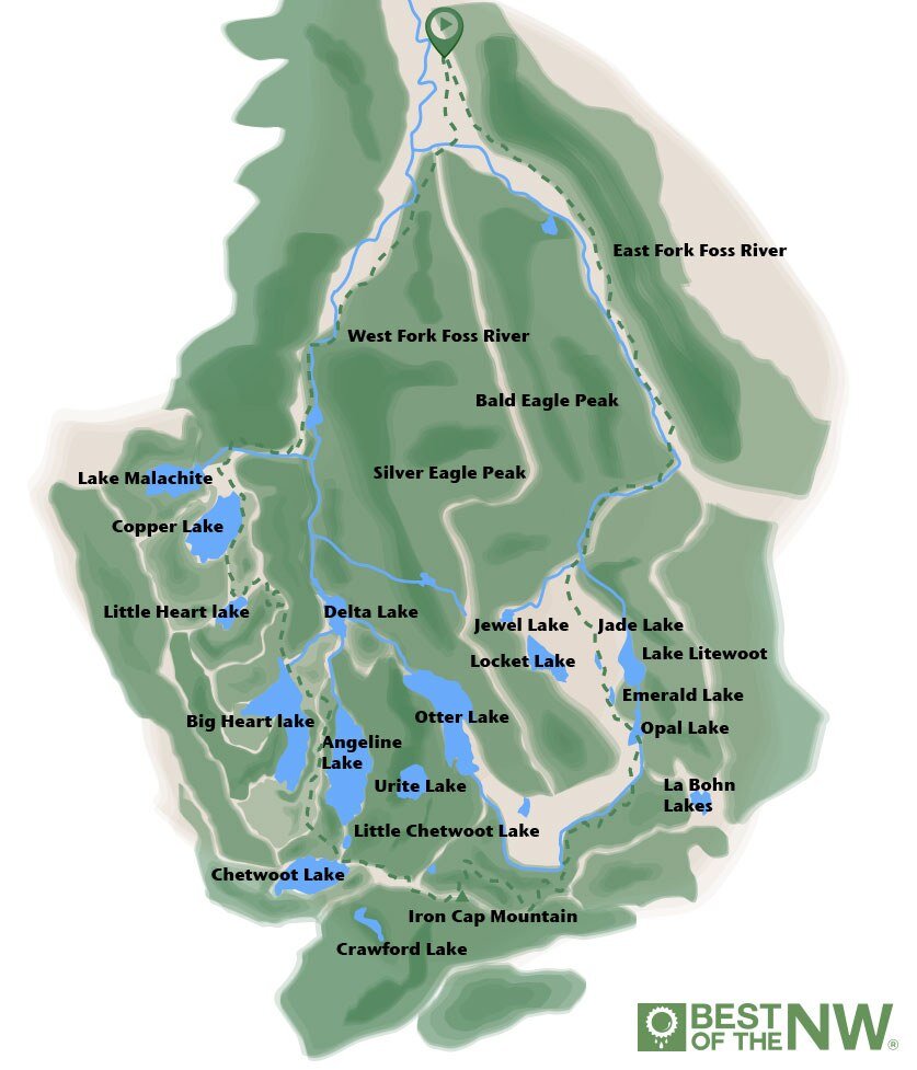
Lake 1. Trout Lake Lake 2. Copper Lake Lake 3. Little Heart Lake Lake 4. Big Heart Lake Lake 5. Delta Lake Lake 6. Angeline Lake Lake 7. Little Chetwoot Lake Lake 8. Chetwoot Lake Lake 9. Azure Lake Lake 10. Urite Lake Lake 11. Crawford Lake Lake 12. Otter Lake Lake 13. Bonnie Lake Lake 14. Tank Lake Lake 15. Opal Lake Lake 16. Emerald Lake Lake 17. Jade Lake


Click/Tap for slideshow

Trip Report:

Having been up both the West and East forks of the Foss River we have been looking at connecting the chain as a loop for some time now. Not sure of the difficulty of route-finding terrain etc. in the space between Big Heart Lake, over Iron Cap Mountain and Tank Lakes we decided to conservatively adjust our plan to accommodate an overnight with relative comfort. This trip was intended to be recon to determine if the loop could be safely navigated as a mountain run within a 24-hour period.

We researched trip reports on WTA, trail references from Guidebooks, Beyond Mount Si pages 130 &133 and the Alpine Lakes High Route map from Fred Becky Cascade Alpine Guide #1 page 188. Bringing a detailed topo, compass, and gps topos maps Iphone app all proved to be necessary in route-finding in the Iron Cap Mountain Area as cloud cover became low late in the afternoon drastically reducing visibility.

Packing light backpacking gear I was able to get tent, sleeping gear for two (bro-rito) clothing and overnight gear in my alpine pack at just under 30 lbs. We brought a jet boil, tons of bars aiming for consuming 100-200 calories per hour). We arrived at the Necklace Valley trailhead at 8am taking the second-to-last parking space. Starting the trip with a 2.5-mile walk down the road to connect with the West Fork of the Foss River Trail to Trout Lake. We decided it would be better to get this road stretch out of the way while we were fresh so we would arrive straight back at the car at the trailhead on the way out.

A sleepy owl greeted us along the road and we made good time up to Trout Lake. The trail starts climbing in earnest up to Copper Lake revealing glimpses of waterfalls and giant old growth trees along the way. After taking a dip in the lake and washing our sweaty clothes (it was super humid) we made it to Little Heart Lake in another 40 minutes and climbed to Big Heart Lake in another 40 minutes noticing more cobwebs on the trail indicating a lot less foot traffic on this section. Rising and dropping steeply we were greeted by the dramatic Big Heart Lake where we enjoyed the most pleasant lake swimming of the trip. Never to be undisturbed by the ever-pesky mosquitoes we ate a lunch and didn’t linger too long before heading up the trail that rises along the ridge between Big Heart Lake and Angelina lake. This is in surprisingly good shape and although it rises and falls continuously is relatively well trodden and was fairly straightforward. Go too far on either side and you end up at a cliff above a lake.

The section of benches, pools and trickling waterfalls ascending to Chetwoot Lake was the most surprisingly beautiful section. Reminiscent of a little Enchantments, these benches of infinity pools, trickling streams and min water falls guided us with brilliant views of the ridge where we had just come. Dropping into Little Chetwoot Lake we refilled our water and crossed at the outlet of Big Chetwoot Lake. A camp above the lake was the only trace of other humans we found in the section between the north bank of Big Heart Lake and Tank Lakes. We observed a well-placed camp with tents, boots, gear, but surprisingly no people (maybe they were completely devoured by the mosquitoes). Continuing up the talus field on Iron Cap Mountain views opened up behind us of other alpine lakes with steep cliffy shores. Reaching the ridge of Iron Cap mountain we hoped for a breeze to blow away the pesky mosquitoes. Not even to get a break from them at 6,000 feet on the ridgeline, we pressed on.

Traversing the southern ridge of the peak proved to be exciting. When the way seemed impassable without technical gear we were always able to find a safe passage across the ridge. Dropping off severely to the south we took in views of Crawford Lake and the start of the Middle Fork of the Snoqualmie River. Climbing up over and around rocky ledges we crossed the face of the peak near the summit for a high north ridge. Dropping down to the east sided proved to be the most challenging part of the trip. We cliffed-out once backtracking and following map contour lines to find a grade that was safely passable.

An obstacle course of steep heather, thick brush, moss-covered boulders along with low cloud cover and complex topography to navigate made the way slow going. We were finally able to traverse ledges back across the eastern lower flanks of Iron Cap Mountain. Using the gps iPhone app to double-check our position we made our way back up towards Tank Lakes. Sensing imminent darkness we found a level spot with fresh water and the shelter from mosquitoes in the clouds to make camp for the evening. We woke bright and early to slightly less overcast but increasingly buggy conditions. Using good old-fashioned compass and map along with the Topo Maps iPhone app we were able to navigate as we moved to keep out of reach of the mosquitoes. We saw a tent at Tank Lakes, only the second trace of other humans since leaving Heart Lake.

From here the way was fairly well marked by cairns and navigating the ridgeline to the north of broken snow fields below. Descending miles of talus was made easier by z-poles taking some of the weight off weary knees. Trees began to get taller and foliage thicker as we made our way through mossy Irelandish rock gardens down to Opal Lake. Connecting back to the main trail from the west side of Opal Lake we found the path straightforward and easy to follow past the other necklace lakes. Jade Lake was the last (and coldest) swim of the trip. We were able to pick up the pace the last 7 miles out as the trail became more defined crossing the East fork of the Foss river and following it much of the way out. Despite the pack weight, we jogged a good chunk of the last few miles in anticipation of dry clothes and salty chips back in the car.

Arriving at the Necklace Valley Trailhead around noon, the total moving time was 16.5 hour.
With good fitness, and route-finding ability this route is doable in a day with a very early start.

Maybe next time…


More Alpine Traverses


Learn More

Map

WTA Trail Page